SP Energy Networks (SPEN) has made a £2.3 million investment into technology that creates 3D maps of electricity maps.
It is hoped that this technology – which uses small planes to fly over the power network – will boost resilience throughout the winter months and beyond.
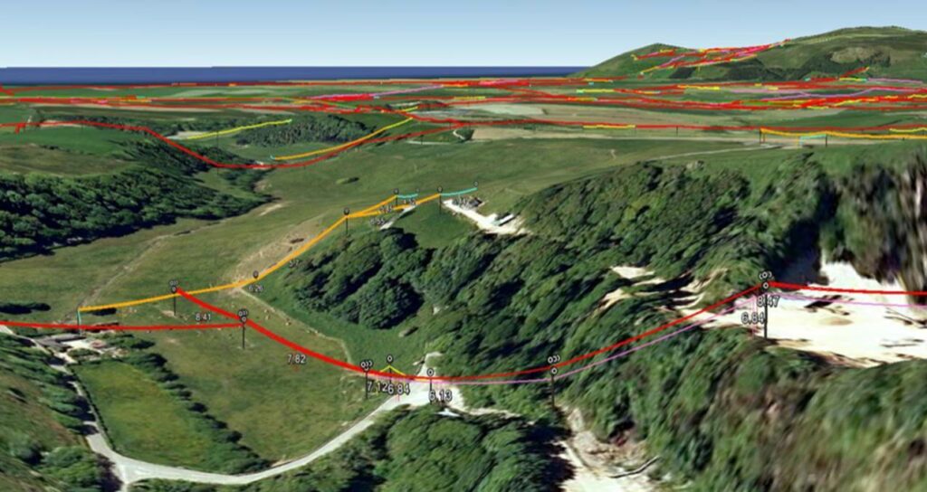
SPEN has undertaken extensive trails of the 3D LiDAR technology, which was developed by geo-data firm Fugro.
The technology captures LiDAR data and aerial imagery to produce a perfect map of the electricity network down to the closest centimeter, the company said. The virtual model will provide a full 3D view of buildings and trees, replacing the traditional onsite surveys that saw a handheld measuring device used.
Although SPEN will still require people on the ground, the LiDAR technology increases accuracy. It is also able to identify changes to the landscape over time that may impact the condition of the network, for instance whether trees and vegetation are growing increasingly close to the power lines, leading it to be trimmed.
Liam O’Sullivan, SP manweb director at SPEN, said that the landscape around its networks is everchanging, which “can cause issues if we are unable to identify potential faults or hazards ahead of time”.
“The LiDAR technology creates agile and precise maps that help us predict everything from tree growth to new infrastructure required,” he said, adding that some winter storms can result in power loss in instances where major lines are hit by trees or other debris and that by identifying potential risks in advance “we can take action ahead of time and reduce the number of impacts”.